NOTE: Best to view blog on computer, however, to
view full blog on phone scroll to bottom of the blog and click on “View Web
Version”. You can click on the Google
Maps tab at the top and click on Year 5, Year 4, Year 3, Year
2 or Year 1 to see where we have been. You can click on the markers on the map to
view the RV Parks we stayed at.
California - Chapter 1 - Petaluma & Groveland
This is our 6-month journey through California from September 2015 through March 2016 broken up into four chapters. California is a huge state which is why it took Sharon so long to get this blog out from 2015! The state is amazing with its natural beauty, diversity, history and things to do. It is also one of the most expensive places we have been! Our budget for one night in an RV Park has been $35. The KOA we stayed at was $60 per night at the time! We would live in California if it weren’t for the fires, landslides, and cost of living. Oh yeah, and the cold and snow! But it was a great adventure! This is Chapter 1 of 4 chapters.
Our first chapter includes San Francisco, Sonoma, Napa Valley, Point Reyes National Seashore, Yosemite National Park, and Bodie State Historic Park to name a few.
Petaluma –
September 14, 2015 to September 28, 2015
We spent two weeks
at San Francisco North/Petaluma KOA. The campground was near San Francisco,
Napa Valley, Sonoma County and the California beaches. We always hit the local farmer's market.


Petaluma is 40 miles north of San Francisco. Over the years, Petaluma has been transformed from a sleepy farming town to a destination full of fascinating nooks. Inhabited by the Miwok Indians and then by the Spanish, the area has a long and proud history that it reveals through well-preserved buildings. Julia Morgan, most famously known for the Hearst Castle in San Simeon, California, was among the designers of Petaluma’s buildings. We took a stroll through the quaint and charming town of art galleries, shops, intimate cafes and elegant restaurants. Sharon’s favorite building was the historic Sonoma County Bank building which is now a seeds and garden supply store.


San Francisco Tour
The KOA tour van
departed the campground daily. There were only four of us and our tour guide
was very interesting. It was a full day with stops to walk around and under the
Golden Gate Bridge, ride a “Rice-a-Roni” Cable Car over Nob
Hill, and shopping and lunch at the historic Fisherman’s Wharf; we enjoyed the Sea Lions at Pier 39.


Our tour included
a drive through San Francisco to see The Presidio, Painted Ladies, Cliff
House/Seal Rock, Conservatory of Flowers, Civic Center, North Beach,
Ghirardelli Square, Golden Gate Park, Performing Arts Center, Haight Ashbury, de Young Museum, Pacific Heights,
Ocean Beach, Ferry Building and Nob Hill. We stopped in Chinatown where our guide told us to walk down an alley to see where fortune cookies were made. We did not make it to Alcatraz this
trip. Maybe next time!


Sonoma and Napa Valley
One day we toured the
wine country in Sonoma. We enjoyed Sonoma’s Historic Square. We took a walk
around the square stopping at several unique shops and had a delightful lunch
at The Girl and The Fig.


 |


We stopped at the Sebastiani Vineyards and Winery. It is one of the few original family wineries remaining. Samuel Sebastiani established the winery in 1904. The wine cellars hold the largest collection of hand carved wine casks in America, some dating back to the mid 1800’s. We enjoyed the sampling of wines which resulted in a purchase of several bottles!


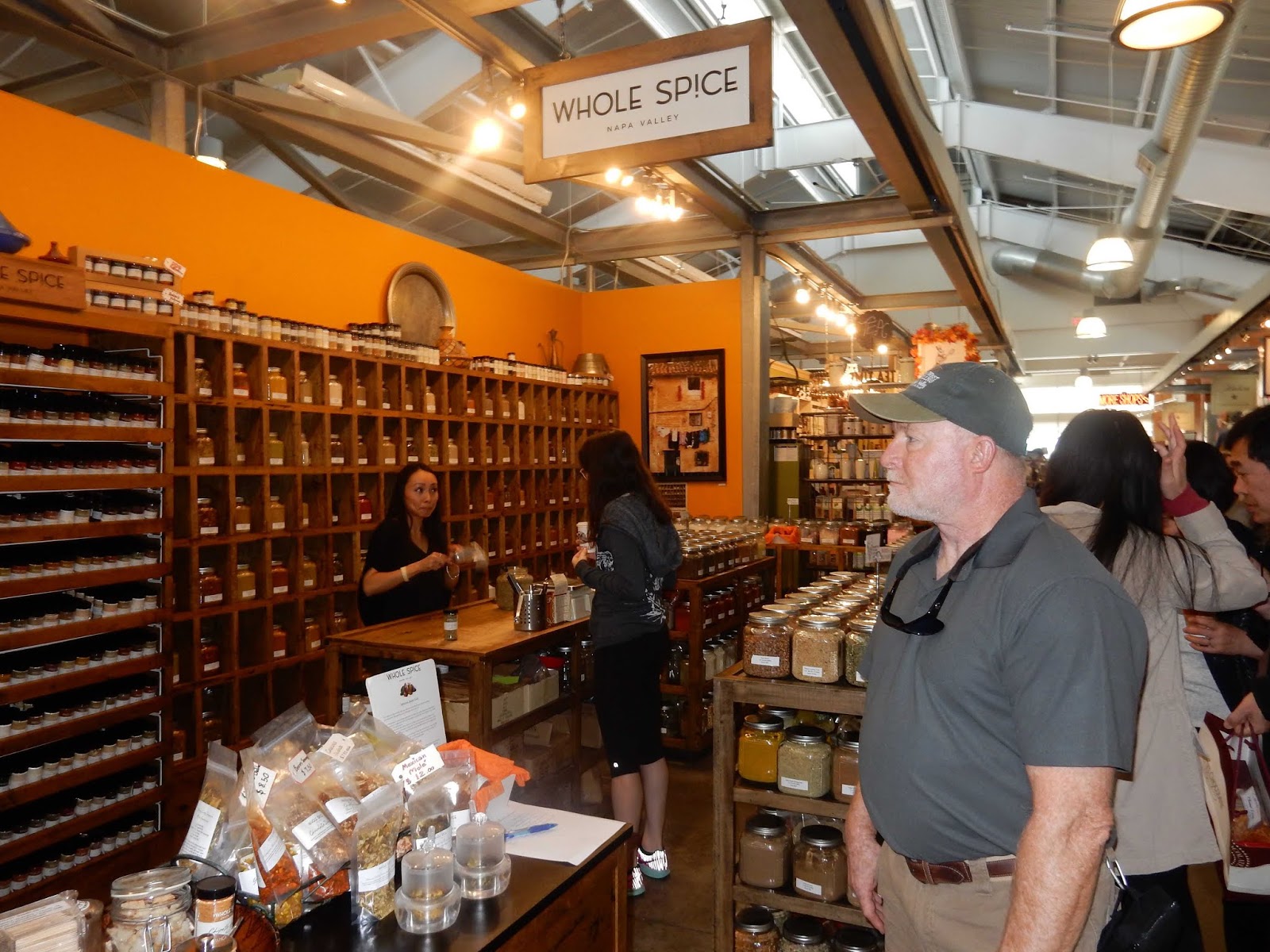
Being the foodies that we are, we could not miss the opportunity to sample foods from the region, so we took a food tour in Napa Valley.


Muir Woods
On another day we
left early for a beautiful drive south to Muir Woods National Monument. It was
named to honor the famed naturalist and writer John Muir. It is a 560-acre park that preserves the only
never-logged, big redwood tree stand, left near San Francisco Bay. Unfortunately, there must
have been a huge event there because upon arrival the parking lots were full,
and the streets were lined with parked cars for miles. We did finally park and
hiked down a trail off the road. It was quiet and we were the only people on
the trail. We did not walk among the 600-year-old, 250-foot tall redwood
giants, but we managed to take a few photos and see a couple of redwood trees!


Historic Point Reyes Lighthouse
After Muir Woods,
we drove along the coast to the historic lighthouse at Point Reyes National
Seashore. Point Reyes is the windiest place on the Pacific Coast and the second
foggiest place on the North American continent. The lighthouse warned mariners
of danger for more than a hundred years. The original first-order Fresnel lens
was manufactured in 1867 in Paris. The
lighthouse was built in 1870 and was retired from service in 1975 when the U.S.
Coast Guard installed an automated light. They then transferred ownership of
the lighthouse to the National Park Service.
It was a cake-walk down to the lighthouse, but the walk back up the 308
stairs was a bear!


When we left the lighthouse, we drove along the National Seashore to the overlook at Drakes Bay to see Elephant Seals. The greatest number of elephant seals haul out on beaches around the headlands from December through March for the birthing and mating season, and in the spring when adult females and juveniles haul out to molt. Some elephant seals may be present on any given day of the year. We were fortunate that by mid-September juveniles will return to shore for a resting haul out. During this time, the juvenile seals are still growing and being onshore allows their bones and muscles to develop properly. It also gets them in sync with the coming on shore twice a year pattern and allows the seals to do this before the breeding season, in which they are too young to participate.


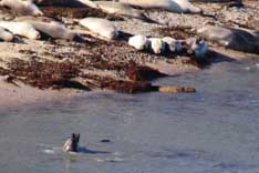


To our surprise, we also saw a couple of freshwater river otters from the overlook, which was unusual since they were swimming in the sea.


Mike went back to
the Jeep to get his binoculars and on the way back he saw a coyote! As we left
Drakes Bay we were on the lookout for the coyote and as luck would have it, we
saw the coyote as it traversed along the seaside!


The coyote was not the only one looking for lunch!


Tin Can Tourist
The KOA hosted the
8th Annual West Coast Vintage Rally Open House & Trailer Yard
Sale. It was a great time looking and touring all of the pre-1970’s vintage
trailers, many towed by equally vintage cars and trucks. It was a step back in
time. We enjoyed talking with everyone and the BBQ lunch was a bonus!


Jelly Belly Factory Tour
We love taking
tours of factories to see how things are made. We signed up for a
behind-the-scenes tour at the Jelly Belly Factory and it was just the two of
us! We had to put our hair (what Mike had of it) in hair nets. We had to put all
our belongings including jewelry, watches, purse, and wallet inside a locker.
Then we had to put footies over our shoes. No photos allowed, so Sharon was disappointed
she had to put her camera in the locker too.


The factory was so clean. We learned a lot about how the Jelly Belly candies are made and got to taste some in the initial stages. The gift shop was full of all flavors of Jelly Belly candies with samples to try. We bought a bunch for our friends and us including some from the cocktail classics, Cold Stone Creamery, sour, and berry flavors. For those with a great sense of humor we bought some from the Bean Boozled selection, including stinky socks, rotten egg, canned dog food and booger! It was a fun way to spend a day!


Groveland – September 28, 2015 through October 12, 2015
We stayed at the
Yosemite Pines RV Resort in Groveland, California for two weeks so we could
explore Yosemite National Park and the surrounding area. Yosemite Pines is in
an area originally called San Ignacio Flat, but also became famous for its
hangings and earned the name Second Garrote. In fact, the “Hangman’s Tree” can
still be viewed not far from the entrance.


We walked through the town of Groveland and ate lunch at the historic Iron Door Saloon. It first became a saloon in 1896 and was named Jake’s Place. In 1937 it was renamed The Iron Door Saloon after the hefty iron doors which had been hauled in on mule back across the Tuolumne River by way of Wards Ferry. These iron doors were manufactured in England and brought around the tip of South America by sailing ship and sold to the saloon as a fire protection device. The idea was that if the town was burning, you just shut the doors and waited it out! The front and back walls are made of solid granite blocks. The sidewalls are made of “shist” rock and mortar and the roof consists of three feet of sod, covered by tin. There were some interesting old buildings in the area.


Yosemite National Park
Created in 1864 as
a forest reserve by President Lincoln, Yosemite has grown into an American icon
of wilderness. From the 3,000-foot-tall
El Capitan to Half Dome, Yosemite’s beauty is unrivaled. It is the nation’s
third National Park and preserves over 747,956 acres which is known for its
waterfalls, giant granite cliffs and stunning sequoias.


Our first visit to the park via the Groveland Entrance, included the visitor center, Yosemite Museum and the Valley Floor Tram Tour. It is always interesting to see the visitor center film about the park and talk with the ranger about hiking trails.


The Yosemite Museum displayed the cultural history of the Miwok and Paiute people from 1850 to the present. The first residents of the Valley were Native Americans. They were called the Southern Sierra Miwok. The Miwok called Yosemite Valley Ahwahnee, which basically means “Place of a Gaping Mouth,” and called themselves the Ahwahneechee.

Non-Native Americans began moving into the area in the 1830s and 40s. Gold was discovered in 1848 and the area was known as Savage’s Diggings, named for miner James Savage. In the late 1870’s, naturalist John Muir brought more attention to the Yosemite area with his writings about the remarkable trees and other geological formations that could be found in Yosemite.


We enjoyed the Valley Floor Tram Tour, a 26-mile tour of Yosemite Valley. The open-air tram was a great way to learn about the history, geology and wildlife from the National Park Service Ranger.


Yosemite National
Park is home to an estimated 350 to 500 black bears. The bruins thrive in the
park’s rich habitat, nibbling manzanita berries, browsing on grasses, and
crunching acorns before retiring to their cozy dens for the winter. Lucky for
us we did not have a bear encounter, although Mike would have loved to see one
up close and personal!

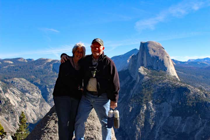
We stopped at the Tunnel View Overlook to see a sweeping view of El Capitan, Bridalveil Fall, and Half Dome. El Capitan a massive granite monolith – the largest in the world – towers 3,593 feet above the Valley floor and is coveted by climbers. Bridalveil Fall is a 620-foot waterfall.

Half Dome is an
iconic, 8,839-foot granite monolith that rises over Yosemite Valley and is a
popular and challenging hike. Half Dome’s cables stretch up an especially steep
granite shoulder to the summit. The hike is 14 miles round-trip on the Mist
Trail, 16.4 miles round-trip on the John Muir Trail and takes roughly 10-12
hours to complete. Not a hike for the faint-hearted or us for that matter!

We hiked 1.6 miles
round-trip on the Footbridge Trail that climbs 400 feet in elevation gain to see
the 317-foot Vernal Fall.


Mike continued and hiked the steep incline to the top of Vernal Fall while Sharon rested. Unfortunately, this time of year, Yosemite Falls, one of North American’s tallest waterfalls, did not reflect the magnificent falls that flowed with the spring runoff.


That afternoon we also took a tour of the Ahwahnee Hotel. The park’s luxury hotel was built in 1927 and is a National Historic Landmark. The original design showed an impressive building consisting of a central tower seven stories high, with three extending wings. The east wing contained an entry lobby and two floors of private rooms, the south wing contained a Grand Lounge, meeting rooms, and three floors of private rooms, and the west wing contained an enormous dining room, seating 350.


To reduce the hotel’s vulnerability to fire, the structure contained little wood. The primary building materials were steel, granite, and concrete. The exterior was to be granite and concrete which would be stained to look like redwood. Today, the main building is 150,000 square-feet and contains 93 rooms, 6 of which are suites. On the grounds east of the Ahwahnee are eight bungalows containing an additional 24 rooms.
At the end of our
tour, we watched some rock climbers behind the hotel.


Columbia State Historic Park
We stepped back in
time to the Gold Rush era when we visited Columbia State Historic Park. Located
in the heart of the Sierra foothills, Columbia State Historic Park is a living
gold rush town featuring the largest single collection of existing gold
rush-era structures in the state. The well-preserved town featured docents that
bring the 1850’s mining town to life, along with a variety of shops, historic
museums, restored 19th century buildings, and restaurants.


Like many mining towns, by 1852 Columbia had a sizeable population of Chinese, French, Irish, Italian, German and Jewish miners and merchants who contributed to the growing cultural and ethnic diversity of Columbia. By 1853, Columbia was one of the largest cities in California, with an estimated population of 25,000 to 30,000. Between 1850 and the early 1900’s, as much as $150 million in gold was mined here. Gold from Columbia helped to finance the United States government and the Union Army during the Civil War. As mining dwindled in the late 1860’s, Columbia began to decline. Miners tore down the vacated buildings and mined vacant lots in search of gold in the crevices of the limestone bedrock on which the town was built.


By the 1940’s the buildings had deteriorated to the point that many were considered unsafe. When Columbia became a state park in 1945, restoration efforts began on the 150-year-old structures to capture and preserve their historic value.
Jamestown - Railtown 1897 State Historic
Park
Colonel George F.
James, a lawyer from San Francisco, became a gold speculator with Native
American miners and other miners working for him. He enjoyed a lavish lifestyle
with a huge, well-stocked tent and trading post. The town was named in his
honor. Jamestown was a fast-growing center of mining, transportation and trading
activity.


While in Jamestown we visited Railtown 1897 State Historic Park to travel back in time to the exciting days of steam-train travel. The park features an authentic railroad depot with locomotives, vintage passenger and freight cars, and historic buildings.


Pieces of the old infrastructure have appeared in over 200 movies and television shows, including High Noon, Back to the Future III, Rawhide, Death Valley Days and the Great Bank Robbery.


Jamestown’s Main Street is lined with antique and gift shops, fine restaurants and historical hotels.


Historic Angels Camp
Angels Camp is known
for mines, writers and frogs! Also known as the City of Angels named for Henry
or George Angel. There is a debate over which brother the town was named for.
Most favor Henry, a shopkeeper from Rhode Island who moved to town in 1848. Early
miners struck gold, and, within a year, more than 4,000 miners were working the
surface gold of Angels Camp. We strolled through the town and ate lunch at
Crusco’s Ristorante.


In 1865, Mark Twain wrote his first successful short story, “The Celebrated Jumping Frog of Calaveras County,” and Angels Camp became forever linked with frogs! The Calaveras County Fair and Jumping Frog Jubilee is held at Frogtown, the county’s fairgrounds, each May. Small fortunes were won and lost by the jump of a frog.


Mariposa - California State Mining and Mineral Museum
We visited the
California State Mining and Mineral Museum in Mariposa. The museum’s collection
began in 1880, including exceptional specimens of California’s gemstones and
minerals, such as gold, silver, copper and platinum. It also includes original
mining artifacts and historical documents, precious mineral and gem specimens
from all over the world.


In 1880 State legislators established the California State Mining Bureau. One of the vital services offered by this new agency was classifying and identifying minerals found anywhere in California. Before long, the new bureau was inundated with specimens submitted for identification from all over the world. The museum was transferred to California State Parks in 1999 and is the only state park without any associated land. The museum collection has grown tenfold since its beginning and holds over 13,000 specimens, with about 350 rotating on display at any one time. No taking of photographs was allowed inside.
In 1906, benitoite
(ben-ee-toe-ite), a stone whose crystals occur in colors from clear through
light blue and light pink, to violet, was discovered at what is now the
Benitoite Gem Mine in San Benito County. The mine is still the world’s only
source of gem-quality stones. The museum had a beautiful specimen of Benitoite, California's state gemstone. We tried to find this gemstone for our
collection, but it is so rare and expensive. However, we later found a tiny
faceted Benitoite (.38 carats) at the Tucson Gem Show!! A rare find!


While in the town of Mariposa we stopped at a bead store and Sharon found some Mariposite beads and pendants to make jewelry. It is a mineral which was named after the town of Mariposa. It can be found in several places in the Sierra Nevada mountains. The term "mariposite" refers to the stone in which green mica is found. The stone is marble, containing varying amounts of dolomite and quartz. Mariposite jewelry is sometimes sold under the trade name "Emerald Quartz".

Sonora is nestled
in the foothills of the majestic Sierra Nevada Mountains. Miners from Sonora,
Mexico, arrived first and settled what they called the “Sonorian Camp”. It
became the biggest, wildest, and richest in the southern Mother Mode. Men from
the eastern United States, Canada, Europe, South America, China and the South
Pacific followed. Known as the “Queen of the Southern Mines,” Sonora incorporated
on May 1, 1851, making it the 11th oldest city in California. Today,
with its many well-kept Victorian homes and its narrow streets that wind in and
out of the hills, Sonora is a sparkling city with a strong feeling for its
historic past. Buildings like St. James Episcopal Church, better known as the
Red Church, remain like visual guideposts to the past.


While in town, we visited the Sonora Fire Museum. With the rush of miners into the area, Sonora was built quickly and without much planning. Nearly all buildings were constructed with wood and were connected to other buildings or tents. As a result, fires occurred with regularity and often destroyed major parts of the town.


Volunteer Fire Department was organized in 1852. Today, the rich history of the Sonora Volunteer Fire Department and the old equipment is charged to the members of Eureka Engine Company # 1 and Independent Hose & Chemical Company # 2. The museum includes Sonora’s first pumping apparatus, the Eureka No. 1. It was made by L.S. Button and Sons of Waterford, NY in 1876 and shipped around Cape Horn to San Francisco. It was then delivered to Sonora where it served as the first line of defense until 1937.


Chinese Camp
About 1849, a
group of Englishmen employed many Chinese miners at this place that came to be
known as Chinese Camp. At one point the town was home to an estimated 5,000 Chinese. A busy village in its day with gold mining and stage
lines, the first Tong War in the state was fought about three miles away near
Crimea House between the Sam Yap and Yan Woo tongs. The battle was fought with pitchforks, rakes
and other mining and farm tools. The historical landmark is part of the Mark Twain Bret Harte Trail.


Period buildings still stand such as the 1854 stone and brick building later used for many years as a post office. The post office was established in the general store and has been in continuous use since 1854. Rosenbloom’s store was one of the Camp’s first permanent buildings and was built of adobe and stone in 1851. The iron doors are the originals which were closed at night to prevent flames spreading into the interior in the event of fire. A brick façade now covers the original adobe and stone. Its iron doors are the original ones. It is one of the few post offices in the state with outside boxes for public use. Eddie Webb was one of the last of the stage drivers in Chinese Camp.


Bodie State Historic Park and Rockhounding
in Lee Vining
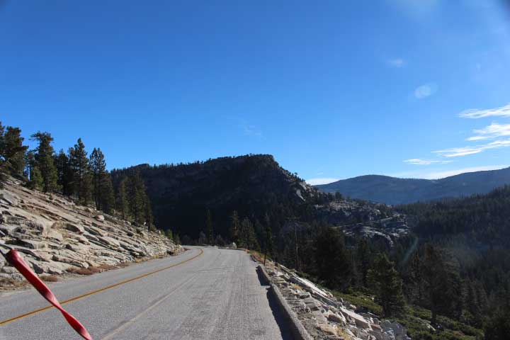
We took a road
trip east on Historic Highway 120 over the 9,945-foot Tioga Pass, the highest
point on the highway and the easterly gate to Yosemite National Park. The
39-mile scenic drive took us through forests and past meadows, lakes, and
granite domes. The turnouts offered broad and stunning vistas. We stopped at Tenaya Lake, an alpine lake at an elevation of 8,150 feet.


When we reached Lee Vining, we ventured onto a dirt road that went on for miles and miles and miles!! Finally, we reached the Bodie Ghost Town. During its boom in the 1870’s, Bodie was home to more than 10,000. Now preserved as Bodie State Park and in “arrested decay,” we were able to see things exactly as they were left when the town was abandoned. It was one of the best ghost towns we have been to.


W.S. Bodie, from Poughkeepsie, NY discovered gold here in 1859. He died several months later in a blizzard, never seeing the town that honors him. The town’s name came to be “Bodie.” During 1877-1881, Bodie’s mining district included 30 different mines and 9 stamp mills. Along with miners and merchants, Bodie attracted a rougher element, who gave the town a reputation for bad men and wild times. There were more than 60 saloons, many near Bonanza Street prostitutes’ “cribs” and opium dens in Chinatown. The ghost town has houses built in the 1870’s, the Methodist Church built in 1882, the Standard Mill from the late 1890’s, gas pumps from the 1920’s, the firehouse, and a schoolhouse that was used until 1942.


Rockhounding on Obsidian Dome
After exploring
Bodie, we went rockhounding at the 600-year-old Obsidian Dome volcano. It is a
mile-long 300-foot high black glass lava dome located near Mammoth Lakes,
California. It is a geological wonder! Climbing on top of a large hill of black
glassy rocks feels like you are walking on the moon. Obsidian Dome is a natural
dome formed from solidified lava, part of the Mono-Inyo volcanic chain.
Extremely hard and brittle, obsidian rock has been used for arrowheads and
stone tools for hundreds of thousands of years.


This concludes Chapter 1 of our first adventure through California. The adventure continues in Chapters 2, 3 and 4.
Drop us an e-mail. We always enjoy hearing from
you!
Mike & Sharon
“Between
every two pines is a doorway to a new world.”
John Muir