NOTE: Best to view blog on computer, however to
view full blog on phone scroll to bottom of the blog and click on “View Web
Version”. Be sure to click on the RV Schedule tab at the top
of the page in the menu bar to see where we will be. You can also click on
the Google Maps tab at the top and click on Year 4, Year
3, Year 2 or Year 1 to see where we have been and where we are going. You can
click on the markers to view where we stayed. If you want to meet up with us,
see the RV Schedule and let us know so we can spend some time with you!
Crescent,
OR – 8/23/17 thru 9/6/17
We stayed at Big
Pines RV Park again after we parted ways with our friends after the Total
Eclipse. We stayed here so we could get to see Crater Lake. However, due to all
the wildfires that pretty much surrounded us, we were unable to venture
outdoors. The smoke was so thick that there were warnings on the poor quality
of air, urging people to stay inside. But there were a few days that allowed us
to get out of the “house”!
Cascade
Lakes Scenic Byway
We took a drive
along the Cascade Lakes Scenic Byway from Crescent to Bend. The scenery was
beautiful! The byway is a National Scenic Byway in central Oregon that runs 66
miles in the rugged country of the Deschutes National Forest along the east
side of the Cascade Range. We stopped at
several alpine lakes along the way. Lava
Lake is home to a quaint resort with a marina, lodging and camping.


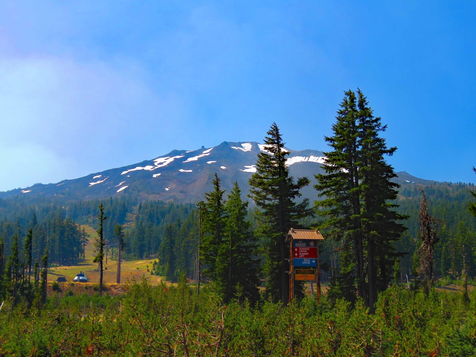
Our last stop was Mt. Bachelor that boasts dry powder and a 3,300-foot elevation drop during the ski season. In the off-season, Pine Marten Express ski lift takes tourists up to the 9,065-foot peak! You can see for hundreds of miles from Mt. Adams in Washington to Mt. Shasta in California. The landscape around Bachelor includes dark lava flows, pale pumice fields, lofty domes and deep chasms – evidence of the fierce volcanic activity that shaped it.
Art Show in Old Mill District in Bend
The Old Mill
District is a historic area in Bend along the Deschutes River. Bend was
formerly occupied by two lumber mills since 1916. For 78 years, the mills
dominated Bend’s economy. At the peak, the mills were two of the largest pine
sawmills in the world. Today, one of the old mill buildings now houses REI, the
outdoor adventure store.

We strolled around the Art in the High Desert, a juried art festival with over 115 nationally acclaimed artists. We especially liked the Fobots (Found Object Robots) booth. Mike loves recycled art! Take a look at their website at www.ifobot.com.

The Old Mill
District is a charming shopping destination with a lot of eateries, galleries
and shops! After the art show, we ate lunch at Anthony’s Restaurant and shopped
at REI.


Due to the constant smoke conditions, the visibility never improved, so Crater Lake and the Newberry Caldera had to remain on our to-do list; maybe this spring when we make our way up through Nevada and Idaho!
Tionesta,
CA – 9/6/17 thru 9/13/17
We stayed at the
Hawk’s Nest Tionesta RV Park tucked away in the Modoc National Forest at the
base of Timber Mountain located just 15 minutes from Lava Beds National
Monument. The RV park was almost empty. It is definitely an out-of-the-way
location, but we really enjoyed our stay and the proximity to the Lava Beds.


Lava Beds National Monument
Lava Beds National
Monument was established in 1925. There was so much to see and do at this park
from hiking to exploring caves to scenic drives. The caves found here were
created by flows of smooth lava 10,500 to 65,000 years ago. As the lava cooled,
caves formed and created homes for unique cave life to thrive. The caves range
from least challenging to moderately challenging to most challenging which
require lighted helmets, knee pads, and gloves for crawling.


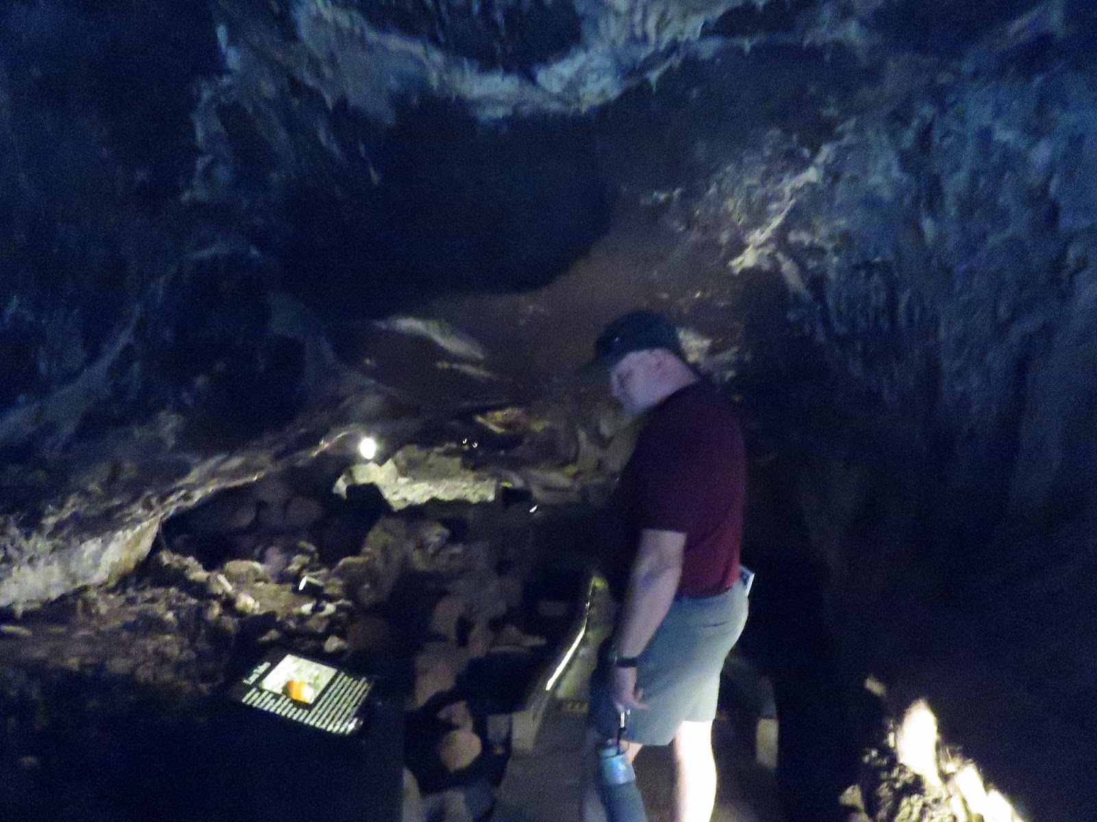
Caves
From the visitor center we followed a trail to the Mushpot Cave. The interpretive signs explained the formations, ecology and cave climate.

We also hiked to Skull Cave. We took our lights to find our way in the darkness. The cave is a remnant of three very large lava tubes, one on top of the other. This allows cold winter air to be trapped inside and create a year-round ice floor on the lower level. It is named for the bones of pronghorn, bighorn sheep, and two human skeletons discovered inside.
Hiking
Lava Beds has
twelve hiking trails. The most popular trails are short, but lead to
interesting historic sites and geological features.
Captain Jacks Stronghold was a 1.5-mile trail through the trenches
of the Stronghold where a small band of Modoc people were forced to spend the
harshest months of the winter of 1872-1873 while army soldiers launched an
assault on this virtual fortress of lava. Hospital Rock, one of the sites from
which the Army attacked, is also visible from high points with the Stronghold.


The Modoc War began on November 29, 1872, when troops from Fort Klamath tried to force the resisting Modoc back to the reservation. They fled to the natural fortress of the lava beds, to what is today called “Captain Jacks Stronghold.” Modoc leader Kientpoos, called Captain Jack by settlers, refused to accept the poor conditions on the reservation. He felt by returning to their homeland and traditional ways his people could have a good life. It took the Army five months to drive the Modoc from the Stronghold. The Stronghold fortress enabled the Modoc fighting force of less than sixty men to hold off an Army twenty times their strength. Kientpoos surrendered on June 1 and was later hanged with three others. The cultural identity of an entire people was lost here, so settlers could graze a few cows.
At the end of our hike, we saw prayer ribbons and sage offerings hanging on the medicine pole signifying the continuing importance of this special place. It is believed that a medicine flag hung from the high point silhouetted against the sky. The fortification beside the trail at this stop was constructed by the soldiers after the Army occupied the Stronghold.

Petroglyph Point is an interpretive walk along a formation that was created when volcanic tuff erupted from the floor of ancient Tule Lake to form an island. At one time this island was the shoreline of Tule Lake. Settlers desire for farmland and water have reduced the lake to 1/6 its former size. Waves undercut the cliff, and early Modoc people paddled out in canoes to carve images into the soft rock.

Petroglyph Point is home to many birds. The high bluff provides protected nesting and roosting sites close to abundant feeding grounds. We saw many mud nests built by cliff swallows.


A short side road takes you to the fascinating Fleener Chimneys. This spatter cone was created as erupting globs of molten lava piled up on each other like sticky oatmeal, leaving a 50-foot-deep chimney behind in the center. We ate a picnic lunch under the juniper trees before hiking up to the chimneys. We saw a woman taking a selfie on top of the chimney.


Mike wanted to hike up a very steep .7-mile trail to the 5,302-foot historic Schonchin Butte Fire Lookout that was built by the Civilian Conservation Corps. Sharon looked up the steep hill and decided to wait for Mike’s return! She hiked up a short way to sit on her hiking stool under the shade of a juniper tree and took photos of nearby flowers and trees.


It took Mike about 45 minutes to hike 460 feet above the trailhead. Mike saw Sharon below and Sharon looked up and saw Mike waving!


Mike had a clear view of Mount Shasta but the clouds did not cooperate! Yet he did get some nice photos of the snow-capped mountain.

Forty-five minutes later, Mike came down the hill, winded from his steep hike, commenting that I would not have made it!!


One of our last stops was Canby Cross, a memorial named after General E.R.S. Canby, who was killed at this location while trying to negotiate peace terms with the Modoc Indians on April 11, 1872. His death was a precursor to a second battle at Captain Jack’s Stronghold. Sharon stayed in the car and when Mike started walking back to the car, she saw Mike’s encounter with a snake on the trail! Mike, intrigued by the colorful snake, stopped and took photos.


Scenic Drive
As we drove along
the main road, we stopped to view Devil’s
Homestead, a lava flow in the valley below.

Then we drove the Tulelake National Wildlife Refuge’s Wildlife Tour Route along the edge of modern-day Tule Lake for a more in-depth birding experience. Waterfowl are especially abundant here in the spring and fall as they pass through on their journey along the Pacific Flyway. We enjoyed seeing a Kestral, Hawk and other birds along the shore of Tule Lake.


At the end of the day we drove 13 miles on a dirt road to Medicine Lake. If it didn't take an hour to drive the dirt road, it would have been a nice lake to kayak on!

Tulelake-Butte Valley Fair
For a small town,
they sure put on a huge Fair! From bag racing to old equipment, to various
exhibits including a reptile exhibit and photo exhibit, to livestock and music,
lots of rides and activities! We also toured through the Museum of Local
History.


The museum also featured one of the barracks and a guard tower left from the Tule Lake WWII Japanese Segregation Center. Barracks from the Japanese Internment camp were given to the homesteaders following WWII and remodeled into homes. Some remain in use today scattered around Tulelake. The barracks show a glimpse into the life of a homesteading family following World War II.


The Tule Lake Segregation Center, began as one of ten relocation centers established throughout the United States. During World War II the camp held 18,789 of the 120,000 men, women, and children of Japanese ancestry who were displaced from their homes and forcibly moved to the Centers. It was transformed into a Segregation Center in 1943 when a Loyalty Questionnaire was used to separate the supposedly “loyal” from the “disloyal” internees. On July 15, 1943, the War Relocation Authority announced segregation of any person who has “indicated that their loyalties lie with Japan during the present hostilities or that their loyalties do not lie with the United States” will be segregated. Due to the harsh conditions of the Center, strife and controversy arose. This led to the construction of a stockade, with a jail, and the implementation of martial law.
The World War II
Valor in the Pacific National Monument was established on December 5, 2008
serving as a reminder of the hardships endured on the home front during World
War II. Over 29,000 Japanese-Americans
passed through the gates of Tule Lake Interment and Segregation Camp.
Located just south
of Tulelake, at Newell, the camp was the largest and last to remain in
operation. We drove to Newell to see the
Tule Lake Segregation Center site.


Klamath Falls
On a scenic drive
to Klamath Falls, we stopped at Outback Rocks where we met Frank, the owner.
Mike wanted to find some Rainbow Obsidian to add to our rock collection. Frank
showed us some beautiful slices of Rainbow Obsidian that we purchased so Mike
could cut and polish them; and Sharon could design some rings or pendants! Mike
also bought Sharon a cabochon of Oregon Pink Opal, mined locally, to create a
pendant.
It was a beautiful
drive over the mountains to Klamath Falls where we celebrated our 42nd anniversary
with a delicious steak dinner at Rooster’s Steak & Chop House.
Standish,
CA – 9/13/17 thru 9/17/17
We stayed at the
Day’s End RV Park, a small park in the heart of the historical town with
beautiful views of the Sierra and Cascade Mountains.
Lassen
Volcanic National Park
The main reason we
selected this area was to see the Lassen Volcanic National Park. It was a 1.5-hour
drive from the RV Park. We entered the park at the Yah-mah-nee Visitor Center
located at the park’s southwest entrance. We watched the 20-minute film about the
history and geology of the park.

The park contains more than 150 miles of hiking trails. We couldn’t wait to explore. We started at Sulphur works with easy access. It features many steam vents and mudpots.


Since this was our
only day at the park, we decided to take a challenging 2.6 mile round-trip
up-hill hike to Bumpass Hell, the largest hydrothermal area in the park. We didn’t
realize there was another place (besides Yellowstone) that contained mudpots,
bubbling pools and steam vents. The 3-hour hike and Bumpass Hell were
incredible!


On our way out of the park, we stopped at Manzanita Lake to take a photo of the lake with a view of snow-capped Lassen Peak at 10,457 feet.

Historic
Uptown Susanville
We went to
Historic Uptown Susanville and strolled around to see some of the original
historic buildings. Susanville is the second oldest town in the western Great
Basin and was established as a trading post in 1854. It has been a major
trading center and remains the major commerce center for the region. We enjoyed
all the murals throughout town.


We also shopped at the Farmers Market at Pancera Plaza for some home-grown fruits and vegetables. We were surprised at how small it was! The music was great.

We enjoyed a delicious lunch at Lassen Ale Works at the Pioneer Saloon. The historic Pioneer Saloon, at this location since 1862, is the oldest business in Northeastern California. It is the place where Plumas and Lassen county officials licked their wounds and made peace after the Sagebrush War.

Lassen Historical Museum
Next, we went to
the Lassen Historical Museum for some local history. In 1854 Isaac Roop opened
a small trading post in what was then known as Rooptown or Roopville, depending
upon the source. Roopville consisted of approximately 20 homes, a store, hotel,
blacksmith and saw mill. With the discovery of gold in the area in 1956, some
settlers decided to stay for good. Eventually, the town was renamed Susanville,
in honor of Roop’s daughter, Susan. In 1861, Roop was named Governor. The
railroads and the timber industry contributed to the county’s development.
Susanville had two large mills.


Roop’s trading post later became known as Roop’s Fort because it was used during the Sagebrush War, a series of small gun battles fought by residents and deputies from neighboring Plumas County seeking to collect taxes. Roop’s Fort is the oldest building in the county.


It is so nice to
hear from all of you! It’s a great way to keep in touch! Keep those
e-mails
coming!
Mike & Sharon
“Do what you
can, with what you have, where you are.”
Theodore
Roosevelt (1858-1919)