We arrived at the USA
RV Park in Gallup, New Mexico on April 29 and stayed for five days. The reason
we came to Gallup was to see the Bisti/De-Na-Zin Wilderness and Chaco Canyon. The owner of the RV Park was very friendly and helpful in directing us to where we wanted to go.
GALLUP,
NM
Gallup is located in
the “Four Corners Region” of New Mexico, Colorado, Utah and Arizona. It was
founded in 1881 as a railhead for the Atlantic and Pacific Railroad. The city
was named after David Gallup, a paymaster for the railroad. It is the most
populous city between Albuquerque, New Mexico and Flagstaff, Arizona. Coal
mining was a big industry in the early days, with many mines now dormant under
Gallup.
Gallup is often
called the “Indian Capital of the World” for its location in the heart of
Native American lands and the presence of Navajo, Zuni, Hopi and other tribes.
One-third of the city’s population has Native American roots. Gallup’s nickname
references the huge impact of the Native American cultures found in and around
Gallup. A large percentage of the world’s Native art is made in or near Gallup.
In 2011, Gallup
was given the title “Adventure Capital of New Mexico” by the New Mexico State
Legislature. Gallup earned this title, in part, due to its trail development
and creation of the High Desert Trail System, the hiking trails at Red Rock Park,
the Zuni Mountain Trail System in the nearby national forest, as well as the
creation of a municipal motocross/OHV park. Yet, the designation also comes
from the diversity of adventures like hot air ballooning, rodeo, hunting, rock
climbing and mountain biking.
BISTI/De-Na-Zin
WILDERNESS
The
Bisti/De-Na-Zin Wilderness area is part of the Bureau of Land Management and
covers roughly 70 square miles of remote badlands located about 98 miles from
Gallup. It is 5,400 to 6,800 feet in elevation. Translated from the Navajo
language, Bisti means “amongst sandstone.” De-Na-Zin takes its name from the
Navajo words for “standing cranes.” Petroglyphs
(rock art) showing cranes have been found south of the Wilderness.
It was a vast landscape and all we had to go by was a map with descriptions of the surrounding area, along with photos of what we were looking for.
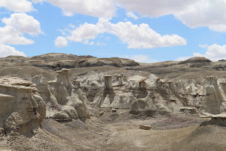
The wilderness features steeply eroded hills and formations that offer some of the most unusual scenery in New Mexico. The Wilderness was once a coastal swamp of an inland sea; and was home to many large trees, reptiles, dinosaurs and primitive mammals. Today is the preserved record of this swamp that is now a true desert wilderness.
There are no
marked trails which is what drew us to this park. The landscape was more like a
“moonscape” with eerily eroded badlands and bizarre hoodoos. Time and natural
elements have etched a fantasy world of strange rock formations made of
interbedded sandstone, shale, mudstone, coal, and silt.
The weathering of the sandstone forms hoodoos – weathered rock in the form of pinnacles, spires, cap rocks, and other unusual forms like mushrooms, arches, and even “cracked eggs.” Fossils occur in this sedimentary landform. Petrified wood and whole tree stumps can be seen eroding out of the hills.
We started our 6-mile hike in the morning. It took about 1 1/2 miles across the "wash" before we came upon something we were looking for.
Following are photos of our entire hike - be patient because each landscape is totally unique and gets better as we go. It was a full day of discovery!
Although we didn’t see any, the wilderness is home to ferruginous and red-tailed hawks, golden eagles and prairie falcons, all of whom nest in the area. Ground-dwelling burrowing owls also nest there, living in abandoned prairie dog burrows. Other birds include pinon jays, ravens, scaled quail, and mourning doves. Gunnison’s prairie dogs, rabbits, coyotes, and badgers live in the wilderness, as do various lizards, snakes, tarantulas, and scorpions.
CHACO
CANYON
Another day we drove to the
Chaco Culture National Historical Park in Nageezi, New Mexico about 95 miles
from Gallup. It has been a World Heritage Site since 1987. The park preserves the monumental
architecture and complex community life of a major center of Ancestral Puebloan
Culture (Anasazi) that took root and flourished for a thousand years. The park’s
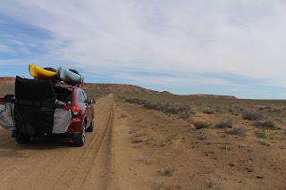
elevation is 6,200 feet. It was quite a long drive along a bumpy dirt road.
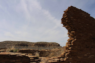
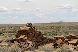
The Chacoan culture began to flourish in the canyon in the mid-800s with continual habitation and building lasting for another 300 years. The Ancient Puebloan people constructed massive stone buildings, called great houses, of multiple stories that are much larger than what had previously been built. Construction on some of these buildings spanned decades and even centuries. These structures were often aligned to solar, lunar, and cardinal directions and placed within a landscape surrounded by sacred mountains, mesas, and shrines. The buildings in the canyon are believed to be “public architecture” that were used periodically by the people for times of ceremony and commerce when temporary populations arrived in the canyon.
By 1050, Chaco had become the political, economic and ceremonial center for the Chacoan culture. Roads connected the canyon to over a 150 other great houses, including Aztec Ruins and Salmon Ruins to the north. Chaco became the trade center for turquoise, parrots, macaws, copper bells and other precious commodities. By the mid-1100s the canyon began to decline as the regional center as new building ceased and influence moved to Aztec Ruins and other great houses. In time, the people moved away from the area and culture to reinvent themselves. Today the Pueblo Indians of New Mexico claim to be the descendants of the Ancient Puebloans.
The majority of the park and cultural sites are self-guided year-round. The first part of the day we took a guided hike to the Pueblo Bonito site.
The remainder of the day we saw two of the five other major sites located along the 9-mile long Canyon Loop Drive including some petroglyphs. The sites included: Una Vida, Hungo Pavi, Chetro Keti, Pueblo del Arroyo, and Casa Rinconada.
As we continued the loop drive to the next stop we happened upon a herd of Elk.
We then stopped to hike up to the Una Vida site and the view was spectacular.
As we left Sharon spotted a lone Elk resting in the shade!
Our next blog post will take you to Mesa Verde, Durango (Train to Silverton) and Pagosa Springs in Colorado!
Mike & Sharon
“Each moment of the year has its own beauty, a picture which
was never seen before, and which shall never be seen again.”
Ralph Waldo Emerson (1803-1882)


